Deep beneath the oceans, invisible to most of humanity, enormous tectonic plates are constantly moving. Where these plates collide, one may sink beneath another in a process known as subduction. These regions, called subduction zones, are among the most dynamic and powerful geological environments on Earth. They generate massive earthquakes, explosive volcanic eruptions, towering mountain ranges, and even devastating tsunamis.
Although volcanic hotspots like Hawaii often receive public attention, subduction zones are arguably the planet’s true geological “hotspots.” They recycle Earth’s crust, reshape continents, and drive many of the natural processes that have influenced our planet for hundreds of millions of years.
What Is a Subduction Zone?
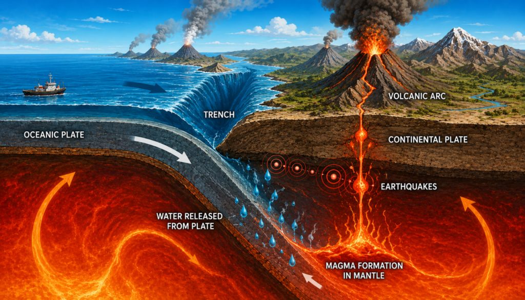
A subduction zone is a boundary where one tectonic plate is forced beneath another and sinks into Earth’s mantle.
This usually occurs when a dense oceanic plate collides with either:
- Another oceanic plate
- A continental plate
Because oceanic crust is denser than continental crust, it typically bends downward and descends into the mantle under the influence of gravity.
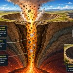
The descending slab gradually heats up as it moves deeper into Earth’s interior, initiating a series of geological processes that shape the planet’s surface.
Subduction is one of the fundamental mechanisms that drives plate tectonics and continuously renews Earth’s crust.
Why Does Subduction Occur?
Earth’s outer shell, called the lithosphere, is broken into large tectonic plates that move slowly across the semi-fluid asthenosphere beneath them.
These plates move because of several interacting processes, including:
- Mantle convection
- Slab pull
- Ridge push
- Gravitational forces
When two plates converge, the denser plate cannot remain above the lighter one.
Instead, it bends downward into the mantle.
This movement occurs at speeds ranging from a few millimeters to over 10 centimeters (4 inches) per year, depending on the location.
Although slow by human standards, these movements accumulate enormous stress over time.
The Birthplace of Powerful Earthquakes
Subduction zones produce some of the strongest earthquakes ever recorded.
As tectonic plates grind against one another, friction prevents smooth movement.
Stress builds for decades—or even centuries.
Eventually, the locked plates suddenly slip.
This rapid release of stored energy generates massive earthquakes known as megathrust earthquakes.
Some famous examples include:
- The 1960 Chile earthquake (Magnitude 9.5)
- The 2004 Indian Ocean earthquake (Magnitude 9.1–9.3)
- The 2011 Tōhoku earthquake in Japan (Magnitude 9.0)
These events rank among the most powerful earthquakes in recorded history.
Why Do Volcanoes Form Above Subduction Zones?
Subduction does not simply recycle Earth’s crust.
It also fuels volcanic activity.
As the descending oceanic plate sinks deeper, it releases water trapped within its minerals.
This water lowers the melting temperature of the overlying mantle.
Partial melting then produces magma.
Because magma is less dense than surrounding rock, it rises toward the surface.
This process forms chains of volcanoes known as volcanic arcs.
Examples include:
- The Andes
- The Cascade Range
- The Japanese Islands
- The Aleutian Islands
- Indonesia
Many of the world’s most explosive volcanoes are located in these regions.
The Pacific Ring of Fire
The world’s largest concentration of subduction zones surrounds the Pacific Ocean.
This region is known as the Ring of Fire.
It contains approximately:
- About 75% of Earth’s active volcanoes
- Around 90% of the world’s earthquakes
Countries located within the Ring of Fire include:
- Japan
- Chile
- Indonesia
- New Zealand
- Mexico
- The Philippines
- The United States (Alaska and the Pacific Northwest)
Because multiple tectonic plates interact here, the region remains one of Earth’s most geologically active areas.
Subduction and Tsunamis
Some of history’s most destructive tsunamis originated in subduction zones.
When a megathrust earthquake suddenly lifts or lowers the seafloor, enormous volumes of seawater are displaced.
This generates tsunami waves that can travel across entire ocean basins.
Unlike ordinary ocean waves, tsunami wavelengths may exceed hundreds of kilometers while traveling at speeds approaching 800 km/h (500 mph) in deep water.
As they reach shallow coastal areas, wave heights increase dramatically, producing devastating flooding.
Modern tsunami warning systems continuously monitor seismic activity in subduction zones to provide early warnings for vulnerable coastlines.
Recycling Earth’s Crust
Subduction acts as Earth’s natural recycling system.
Oceanic crust forms at mid-ocean ridges, spreads outward, and eventually returns to the mantle through subduction.
This continuous cycle:
- Regulates crustal thickness
- Helps drive plate tectonics
- Influences the carbon cycle
- Contributes to mountain building
- Shapes continents over millions of years
Without subduction, Earth’s surface would look dramatically different.
Many scientists believe plate tectonics—and particularly subduction—has played a major role in maintaining the long-term stability of Earth’s climate by participating in the geological carbon cycle.
Can Scientists Predict Major Subduction Earthquakes?
Although scientists understand why subduction earthquakes occur, predicting the exact time and location of a major earthquake remains impossible.
Researchers instead focus on:
- GPS measurements
- Seafloor monitoring
- Satellite observations
- Seismic networks
- Historical earthquake records
These tools help estimate long-term seismic hazard and improve earthquake-resistant engineering and emergency planning.
Preparedness remains the most effective strategy for reducing earthquake risk.
Expert Perspective
Geophysicist Professor Hiroo Kanamori of the California Institute of Technology has made groundbreaking contributions to the understanding of megathrust earthquakes and subduction zone dynamics. His research demonstrated how enormous amounts of energy accumulate along convergent plate boundaries before being released during giant earthquakes. Kanamori’s work has greatly improved seismic hazard assessment and our understanding of the physical processes occurring within subduction zones.
Organizations such as the United States Geological Survey (USGS) also emphasize that continuous monitoring of subduction zones is essential for improving tsunami warning systems and understanding long-term geological hazards.
Why Subduction Zones Matter
Subduction zones are far more than regions of earthquakes and volcanoes.
They regulate Earth’s geological evolution by:
- Recycling oceanic crust
- Building mountain ranges
- Driving volcanic activity
- Influencing the carbon cycle
- Creating new continental crust
- Shaping ocean basins
These immense geological systems have been active for hundreds of millions of years and continue transforming the planet today.
Although they pose significant natural hazards, they are also essential to Earth’s long-term geological stability and have played a fundamental role in creating the dynamic world we inhabit.
Interesting Facts
- The deepest ocean trench, the Mariana Trench, formed at a subduction zone.
- The 1960 Chile earthquake remains the strongest instrumentally recorded earthquake in history, with a magnitude of 9.5.
- Approximately 75% of Earth’s active volcanoes are associated with the Pacific Ring of Fire.
- Some tectonic plates move more than 10 centimeters (4 inches) per year.
- Tsunami waves in deep water can travel at speeds comparable to a commercial jet aircraft.
- Oceanic crust is generally recycled back into the mantle after about 200 million years.
- Subduction helps regulate Earth’s long-term carbon cycle by transporting carbon-rich materials into the mantle.
Glossary
- Subduction Zone — A tectonic plate boundary where one plate sinks beneath another into Earth’s mantle.
- Tectonic Plate — A large, rigid section of Earth’s lithosphere that moves slowly across the planet’s surface.
- Lithosphere — Earth’s rigid outer layer, consisting of the crust and the uppermost mantle.
- Mantle — The thick layer of hot rock located beneath Earth’s crust.
- Megathrust Earthquake — An extremely powerful earthquake occurring along a subduction zone where tectonic plates converge.
- Volcanic Arc — A chain of volcanoes formed above a subduction zone.
- Ring of Fire — A horseshoe-shaped region surrounding the Pacific Ocean characterized by frequent earthquakes and volcanic activity.
- Tsunami — A series of large ocean waves generated by sudden displacement of seawater, most commonly during undersea earthquakes.