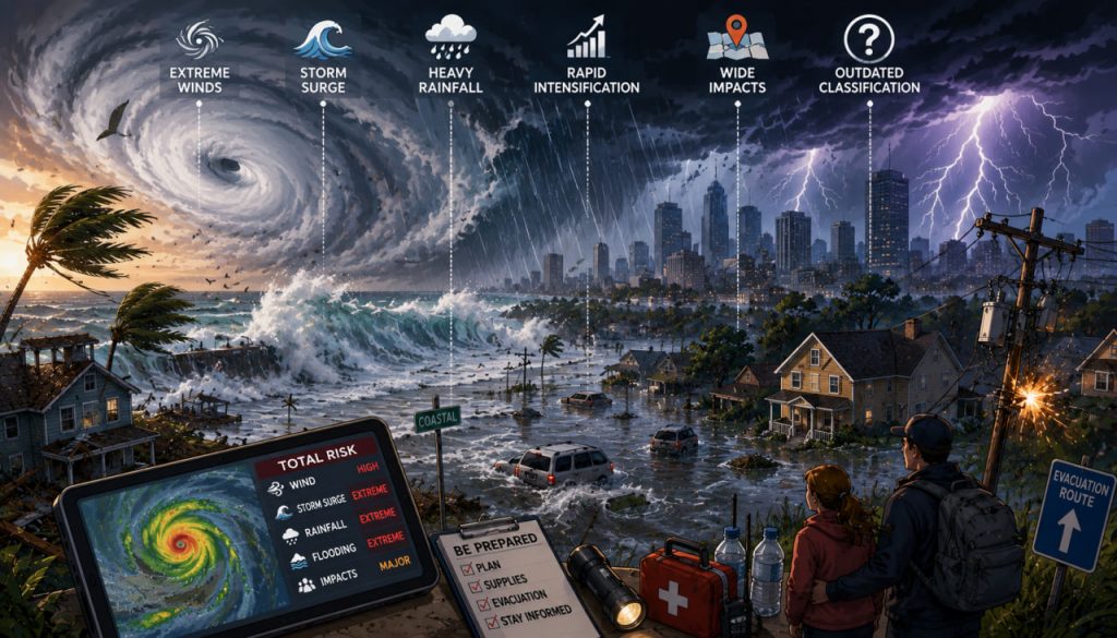
The word superstorm is not a strict scientific category like “Category 4 hurricane” or “tropical cyclone.” It is usually used to describe an unusually destructive storm that combines several dangerous hazards at once: extreme winds, storm surge, intense rainfall, flooding, rapid intensification, and wide geographic impact.
In recent years, the term has become more common because many storms no longer feel adequately described by traditional labels. A hurricane may weaken from Category 5 to Category 2 before landfall but still produce catastrophic flooding. Another storm may not have record-breaking winds but may stall over one region and drop historic rainfall. A coastal cyclone may merge with another weather system and create damage far beyond what its wind rating suggests.
This raises an important question: are old storm categories still enough to communicate modern storm danger? Increasingly, many meteorologists and disaster experts say no.
What Is a Superstorm?
A superstorm is generally an exceptionally powerful or destructive storm system that causes major damage across a large area.
The term may refer to:
- Very intense hurricanes
- Large extratropical cyclones
- Hybrid storm systems
- Storms with extreme rainfall
- Storms with unusually high storm surge
- Large winter storms
- Storms that combine several hazards at once
The term became especially famous after Superstorm Sandy in 2012. Sandy was no longer technically a hurricane when it made landfall, but it caused enormous storm surge, flooding, wind damage, and infrastructure disruption across the northeastern United States.
A superstorm is defined less by one meteorological number and more by its total impact.
How Storms Are Traditionally Classified
The most familiar hurricane classification system in the Atlantic and eastern Pacific is the Saffir-Simpson Hurricane Wind Scale.
It ranks hurricanes from Category 1 to Category 5 based only on maximum sustained wind speed. The U.S. National Hurricane Center states clearly that this scale does not include other deadly hazards such as storm surge, rainfall flooding, or tornadoes.
The basic structure is simple:
- Category 1: Dangerous winds
- Category 2: Extremely dangerous winds
- Category 3: Major hurricane
- Category 4: Catastrophic damage potential
- Category 5: Devastating wind damage
This system is useful for communicating wind risk quickly.
But it is not a full measure of storm danger.
A storm’s category tells you about wind speed, not total threat.
Why Wind Speed Alone Is Not Enough
Many of the deadliest storm impacts come from water, not wind.
Tropical cyclones can produce multiple hazards, including extreme winds, heavy rainfall, storm surge, flooding, lightning, and tornadoes. The World Meteorological Organization notes that when these hazards interact, the overall danger can increase significantly.
A lower-category storm can still be catastrophic if it:
- Moves slowly
- Pushes seawater inland
- Drops extreme rainfall
- Hits a densely populated area
- Arrives during high tide
- Affects weak infrastructure
- Covers a very large geographic area
This is why some “weaker” storms on the wind scale can cause greater losses than stronger storms.
The most dangerous storm is not always the one with the highest category number.
Storm Surge Changes Everything
Storm surge is the abnormal rise of seawater pushed inland by storm winds and pressure.
It can flood coastal communities quickly and severely.
Storm surge depends on several factors:
- Storm size
- Wind direction
- Coastal shape
- Ocean depth near shore
- Tide level
- Forward speed
- Central pressure
A large storm with moderate winds can sometimes produce devastating surge because it pushes water over a broad area for a long time.
This is one reason traditional wind categories can underestimate real danger.
Rainfall Is Becoming a Bigger Part of the Problem
A warmer atmosphere can hold more moisture.
That means storms can produce heavier rainfall when conditions are favorable.
NOAA’s Geophysical Fluid Dynamics Laboratory explains that tropical cyclone rainfall rates are projected to increase as the climate warms, partly because a warmer atmosphere contains more moisture. For a 2°C global warming scenario, modeling studies project an average increase of about 14% in rainfall rates near storms.
The IPCC also states that further warming is associated with increases in heavy precipitation and an increase in the proportion of intense tropical cyclones.
Flood risk is becoming central to storm danger, even when wind categories do not fully reflect it.
Rapid Intensification Makes Forecasting Harder
Another major concern is rapid intensification, when a storm’s winds strengthen dramatically in a short period.
This can happen when storms pass over very warm ocean water and favorable atmospheric conditions.
Rapid intensification is dangerous because it reduces preparation time.
Communities may expect one level of storm risk and then suddenly face a much stronger system.
Warmer ocean temperatures can provide more energy for powerful storms, although each individual storm is still shaped by many factors such as wind shear, humidity, and atmospheric structure.
The faster a storm intensifies, the harder it becomes for people to respond safely.
Why Traditional Classification Is Becoming Outdated
Traditional storm classification is not useless.
It remains valuable for communicating wind risk.
However, it is increasingly incomplete because modern storm impacts often depend on several interacting hazards.
The old category system can fail to communicate:
- Rainfall flooding risk
- Storm surge danger
- Storm size
- Forward speed
- Duration over one region
- Infrastructure vulnerability
- Compound flooding
- Power grid risk
- Urban drainage limits
A Category 1 storm that stalls over a city can be more destructive than a Category 3 storm that moves quickly through a less populated area.
Modern storm communication needs to describe impact, not just intensity.
The Problem with “Category 6”
After exceptionally intense hurricanes, people often ask whether the world needs a Category 6.
Some researchers have discussed whether a higher category could better communicate extremely powerful winds in a warming climate. However, adding another wind category would not solve the main problem: wind speed is only one part of storm danger.
A Category 6 label might describe extreme winds more clearly, but it still would not fully capture:
- Rainfall
- Storm surge
- Flooding
- Storm size
- Duration
- Local vulnerability
The real challenge is building a system that communicates total risk.
Better Ways to Communicate Storm Risk
Meteorologists increasingly use multiple tools instead of relying on one category.
These include:
- Storm surge maps
- Rainfall forecasts
- Flood watches
- Wind probability maps
- Evacuation zones
- Impact-based warnings
- Local emergency alerts
- Real-time radar and satellite updates
Some proposed systems combine wind, rainfall, storm surge, and population exposure into more complete risk indexes.
These approaches may help people understand what a storm will actually do, not just how strong its winds are.
A better warning system tells people what danger they face and what action they should take.
Expert Perspective
Meteorologists at the National Hurricane Center have repeatedly emphasized that the Saffir-Simpson scale is a wind scale only and should not be used as the sole measure of hurricane danger. Their official guidance clearly states that the scale does not account for storm surge, rainfall flooding, or tornadoes.
Climate researchers also stress that warming affects storms in ways that go beyond wind speed. According to NOAA research, rainfall rates associated with tropical cyclones are expected to increase as atmospheric moisture increases.
Together, these perspectives point to the same conclusion: storm classification must evolve from simple category labels toward multi-hazard risk communication.
How People Should Read Storm Warnings
The safest approach is to look beyond the category.
Before a storm, pay attention to:
- Local evacuation orders
- Storm surge forecasts
- Rainfall totals
- Flash flood warnings
- Wind forecasts
- River flood forecasts
- Power outage risk
- Official emergency guidance
A lower-category storm can still be life-threatening.
A downgraded storm can still produce deadly flooding.
A storm far from land can still create dangerous waves and coastal flooding.
Never use the category number as your only guide for safety decisions.
Interesting Facts
- The Saffir-Simpson Hurricane Wind Scale measures only maximum sustained wind speed, not rainfall or storm surge.
- Many hurricane deaths are caused by water-related hazards rather than wind alone.
- A slow-moving storm can cause catastrophic flooding even if its wind speed is not extreme.
- Tropical cyclones can produce tornadoes, especially in outer rainbands.
- Storm surge can occur before, during, or after the center of a storm reaches land.
- Warmer air can hold more moisture, which can increase the potential for heavier rainfall.
- A storm’s size can strongly affect how much coastline experiences damaging winds, waves, and surge.
Glossary
- Superstorm – An informal term for an unusually destructive storm with widespread impacts or multiple severe hazards.
- Tropical Cyclone – A rotating storm system that forms over warm ocean water and includes hurricanes, typhoons, and cyclones depending on region.
- Hurricane – A tropical cyclone with sustained winds of at least 74 mph in the Atlantic or eastern Pacific.
- Saffir-Simpson Hurricane Wind Scale – A 1–5 classification system based only on maximum sustained wind speed.
- Storm Surge – An abnormal rise of seawater pushed inland by a storm.
- Rapid Intensification – A sharp increase in storm wind speed over a short period.
- Extratropical Cyclone – A large storm system outside the tropics, usually powered by temperature contrasts rather than warm ocean water alone.
- Impact-Based Warning – A warning system that focuses on expected damage and protective actions rather than only meteorological measurements.