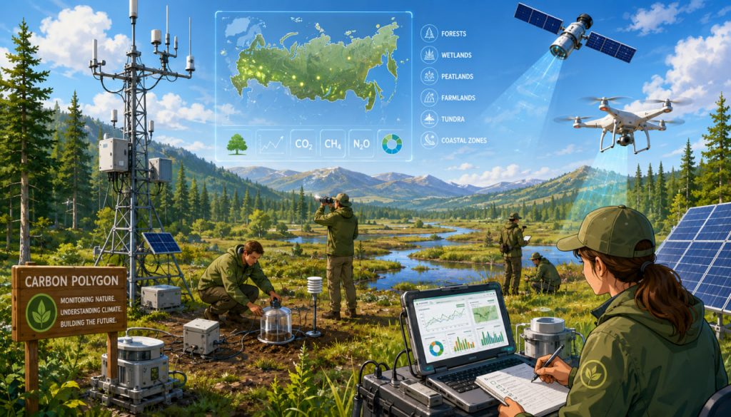
Russia’s carbon polygons are specialized research territories created to measure how natural ecosystems absorb and release greenhouse gases. Forests, peatlands, agricultural soils, wetlands, grasslands, coastal zones, and permafrost landscapes can all act as carbon sinks or emission sources depending on weather, land use, and environmental conditions.
The national pilot project was launched by the Russian Ministry of Science and Higher Education to develop domestic methods for greenhouse gas measurement, verify carbon-balance calculations, train specialists, and test technologies that could eventually support climate policy and carbon management. The project’s official website currently lists 19 active test areas covering more than 39,000 hectares.
Despite the name, a carbon polygon is not primarily an industrial facility or a place where carbon dioxide is stored underground. It is an open-air scientific laboratory for observing the movement of carbon between soil, vegetation, water, and the atmosphere.
What Is a Carbon Polygon?
A carbon polygon is a designated territory equipped for long-term monitoring of climatically active gases.
Scientists study the concentration and movement of:
- Carbon dioxide
- Methane
- Nitrous oxide
- Water vapor
They also collect information about soil moisture, air temperature, vegetation growth, weather conditions, biomass, water quality, and land use.
The official project describes carbon polygons as non-urban test sites where technologies for measuring, monitoring, and controlling greenhouse gases are developed and tested.
The word “polygon” in this context means a testing ground or experimental area. It does not refer to a geometric shape.
Why Russia Needs a Carbon Monitoring Network
Russia contains an enormous range of ecosystems, from Arctic tundra and Siberian peatlands to southern forests, steppes, farmland, and marine coastal zones.
These landscapes do not behave in the same way.
A growing forest may remove carbon dioxide from the atmosphere, while a wildfire can rapidly release stored carbon. Healthy peatland may preserve carbon for centuries, but drained or warming peat can emit carbon dioxide and methane. Agricultural soils may either lose or accumulate organic carbon depending on cultivation practices.
Because of these differences, national carbon estimates cannot rely only on general assumptions or measurements made in other countries.
Russia needs locally collected data that reflect its climate, soils, vegetation, permafrost, and land-management systems.
Scientific models currently produce widely differing estimates of natural carbon dioxide and methane flows across Russian regions. This uncertainty demonstrates why direct observation is important.
How Greenhouse Gas Flows Are Measured
Carbon polygons combine several measurement methods.
One important technology is the eddy covariance tower. Instruments installed on a mast measure rapid changes in wind and gas concentrations. From these data, scientists calculate whether the surrounding ecosystem is absorbing or releasing carbon dioxide and methane.
Researchers also use soil chambers. A chamber is placed over a small area of soil, and sensitive analyzers record how gas concentrations change inside it. This reveals whether the soil is emitting or absorbing greenhouse gases.
At Russia’s Ladoga monitoring site, for example, scientists used chamber measurements to study carbon dioxide and methane flows from wetlands, abandoned agricultural land, and other southern taiga soils.
Additional tools may include:
- Meteorological stations
- Soil sensors
- Drones
- Aircraft observations
- Satellite imagery
- Laser gas analyzers
- Forest inventories
- Water-sampling equipment
- Remote-sensing cameras
Ground measurements are especially valuable for checking whether satellite observations and computer models accurately represent real ecosystems.
What Is a Carbon Balance?
An ecosystem continuously exchanges carbon with the atmosphere.
Plants remove carbon dioxide through photosynthesis and use its carbon to build leaves, roots, trunks, and other tissues. Plants, animals, fungi, and microorganisms return some of that carbon through respiration and decomposition.
A forest may absorb more carbon than it releases during one year but become a net source after fire, drought, logging, or insect damage.
The difference between total absorption and total release is called the carbon balance.
A negative net carbon flow usually indicates that an ecosystem is removing carbon dioxide from the atmosphere. A positive flow means it is releasing more than it absorbs.
Long-term measurements are necessary because a few days or one season cannot represent the behavior of an entire ecosystem.
From Monitoring to Emissions Control
Carbon polygons do not physically stop factory emissions. Their role in “control” is mainly scientific and methodological.
The data can help researchers and authorities:
- Improve national greenhouse gas inventories
- Detect changes in natural carbon sinks
- Evaluate forestry and agricultural practices
- Test methods for restoring degraded ecosystems
- Verify carbon-removal projects
- Identify methane-emitting landscapes
- Develop regional climate models
- Support carbon reporting standards
Some sites also investigate ways to increase carbon absorption. Possible experiments include reforestation, peatland restoration, altered grazing practices, improved crop rotation, reduced soil disturbance, and management of damaged land.
The Mukhrino carbon test area, for example, has studied greenhouse gas absorption in natural and disturbed ecosystems and developed recommendations for reducing emissions and improving land management.
Measurement must come before credible emissions management. Without reliable baseline data, it is impossible to prove that a project has genuinely reduced emissions or increased carbon storage.
Carbon Polygons and Carbon Farms
A carbon polygon and a carbon farm are related but different concepts.
A carbon polygon is primarily a scientific monitoring site. It measures greenhouse gas flows, develops methods, and tests technologies.
A carbon farm is a managed territory where specific activities are intended to increase carbon sequestration or reduce emissions. These activities might include planting forests, restoring wetlands, improving soils, or changing agricultural practices.
Data from carbon polygons may help determine whether carbon-farming projects actually work.
This is important for potential carbon-credit systems. A credible carbon project must demonstrate that the claimed removal is measurable, additional, long-lasting, and not cancelled by emissions elsewhere.
The Importance of Peatlands and Permafrost
Russia contains vast northern peatlands and permafrost territories that store enormous quantities of organic carbon.
Cold and waterlogged conditions slow decomposition, allowing dead plant material to accumulate in soil. However, warming, drainage, fires, and permafrost thaw may accelerate decomposition and release carbon dioxide or methane.
Methane is especially important in wetlands. Although it remains in the atmosphere for a shorter time than carbon dioxide, it produces a powerful warming effect.
Carbon monitoring in northern ecosystems can help scientists understand whether these landscapes will remain carbon sinks or become stronger emission sources as the climate changes.
This is one reason carbon polygons must cover more than ordinary forests. Wetlands, agricultural soils, tundra, coastal waters, and disturbed industrial landscapes all require investigation.
The Main Challenges Facing the Project
The network faces several scientific and practical challenges.
Russia’s territory is so large and environmentally diverse that a limited number of sites cannot represent every natural zone. Researchers have warned that incomplete geographic coverage could distort national carbon assessments.
Equipment must also operate in remote areas with extreme cold, snow, moisture, and limited infrastructure. Continuous monitoring requires regular calibration, maintenance, stable electricity, and trained personnel.
Another challenge is methodological consistency. Measurements from different polygons must be comparable. That requires common standards for equipment, sampling, data processing, quality control, and long-term storage.
Short projects are insufficient. Carbon flows vary with seasons, droughts, fires, floods, and unusual weather. The greatest scientific value will come from uninterrupted observations collected over decades.
Expert Perspective
Soil scientist Evgeny Abakumov and colleagues have argued that carbon polygons can support the study of carbon accumulation, emissions, and storage across Russian ecosystems. At the same time, they caution that the network must adequately represent the country’s major climatic and ecological zones to produce dependable large-scale estimates.
Researchers involved in the international PEEX environmental program have also highlighted the value of connecting Russian carbon sites with broader atmospheric and ecosystem-observation networks. Such cooperation can improve equipment comparisons, data quality, and understanding of greenhouse gas flows across northern Eurasia.
Why the Experiment Matters
Carbon polygons can provide a scientific foundation for climate decisions.
They may help distinguish industrial emissions from natural ecosystem flows, assess the effects of wildfires and land degradation, and determine whether forests or soils are storing as much carbon as models suggest.
They also serve an educational purpose. Universities use the sites to train ecologists, meteorologists, soil scientists, programmers, engineers, and remote-sensing specialists.
The project’s success should ultimately be judged not by the number of sites created, but by the accuracy, transparency, continuity, and practical use of the data they produce.
Interesting Facts
- Russia’s carbon polygon network includes forests, wetlands, farmland, tundra, and marine environments.
- Carbon dioxide is not the only gas measured; methane and nitrous oxide are also important.
- Some soils absorb methane, while wetlands frequently release it.
- A forest can switch from being a carbon sink to a carbon source after fire or severe drought.
- Eddy covariance instruments can measure gas exchange over a wide surrounding area without enclosing the vegetation.
- Soil chambers measure gas flows from a much smaller surface but provide detailed local information.
- Satellite observations require ground-based measurements for calibration and verification.
- Abandoned farmland may gradually accumulate carbon as vegetation returns.
- Peatlands cover a relatively small portion of Earth’s land but store exceptionally large carbon reserves.
- A carbon polygon can include several separated ecosystems rather than one continuous field.
- Researchers can use tree measurements and remote sensing to estimate how much carbon is stored in forest biomass.
- Long-term monitoring can reveal trends that are invisible in a single season.
Glossary
- Carbon Polygon — A field research territory used to measure greenhouse gas emissions, absorption, and ecosystem carbon storage.
- Greenhouse Gas — A gas that absorbs heat in the atmosphere, including carbon dioxide, methane, and nitrous oxide.
- Carbon Sink — A system that absorbs more carbon than it releases.
- Carbon Source — A system that releases more carbon than it absorbs.
- Carbon Balance — The difference between carbon entering and leaving an ecosystem.
- Carbon Sequestration — The capture and long-term storage of atmospheric carbon.
- Eddy Covariance — A method that calculates gas exchange using rapid measurements of wind and atmospheric composition.
- Flux — The rate at which a substance moves through a defined area.
- Soil Chamber — A device placed over soil to measure gases entering or leaving the surface.
- Remote Sensing — Collection of information from satellites, aircraft, drones, or distant instruments.
- Biomass — Organic material contained in plants, animals, and microorganisms.
- Peatland — A wet ecosystem where partially decomposed plant matter accumulates as peat.
- Permafrost — Ground that remains frozen for at least two consecutive years.
- Carbon Farm — Managed land where practices are used to increase carbon storage or reduce greenhouse gas emissions.
- Baseline — A reference measurement used to evaluate later changes.
- Greenhouse Gas Inventory — A calculated record of emissions and removals within a territory or economic sector.
- Verification — Independent checking that measurements or reported environmental results are accurate.
- Nitrous Oxide — A powerful greenhouse gas often associated with soils, fertilizers, and microbial activity.